Spokane River Watersheds
Watershed Planning & Implementation for WRIAs 54, 55, 56, & 57
WRIA 54 Data - Surface Hydrogeology
 WRIA 54 Web Mapping Application
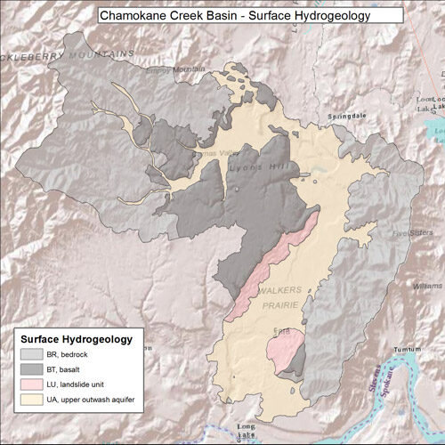
The hydrogeologic framework consists of six hydrogeologic units: The Upper outwash aquifer, the Landslide Unit, the Valley Confining Unit, the Lower Aquifer, the Basalt Unit, and the Bedrock Unit. The Upper outwash aquifer occurs along the valley floors of the study area and consists of sand, gravel, cobbles, boulders, with minor silt and (or) clay interbeds in places. The Lower aquifer is a confined aquifer consisting of sand and gravel that occurs at depth below the Valley confining unit. Median horizontal hydraulic conductivity values for the Upper outwash aquifer, Valley confining unit, Lower aquifer, and Basalt unit were estimated to be 540, 10, 19, and 3.7 ft/d, respectively.
Chamokane Creek Basin surface hydrogeology from USGS Scientific Investigations Report 2010-5165.
Data Descriptions
- Well Logs
- Estimated Well Yield
- Estimated Well Depth
- Nitrate Levels
- Deep Creek & Coulee Creek Flow and Seepage Runs
- Geologic Cross Sections - Chamokane Creek Basin
- Upper Aquifer - Chamokane Creek Basin
- Lower Aquifer - Chamokane Creek Basin
- Valley Confining Unit - Chamokane Creek Basin
- Surface Geology - Chamokane Creek Basin
- Surface Hydrogeology - Chamokane Creek Basin
- Primary Water Bearing Units