Spokane River Watersheds
Watershed Planning & Implementation for WRIAs 54, 55, 56, & 57
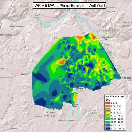
WRIA 54 Data - Well Yield
 WRIA 54 Web Mapping Application
This data layer is the estimated well yeild based on data from existing wells. This data layer was created utilizing inverse distance weighted interpolation, and therefore values between data points are estimates and actual well yields may be different based on localized conditions. If you are seeking information about a specific location evaluate well data in the vicinity in addition to this data layer.
Data Descriptions
- Well Logs
- Estimated Well Yield
- Estimated Well Depth
- Nitrate Levels
- Deep Creek & Coulee Creek Flow and Seepage Runs
- Geologic Cross Sections - Chamokane Creek Basin
- Upper Aquifer - Chamokane Creek Basin
- Lower Aquifer - Chamokane Creek Basin
- Valley Confining Unit - Chamokane Creek Basin
- Surface Geology - Chamokane Creek Basin
- Surface Hydrogeology - Chamokane Creek Basin
- Primary Water Bearing Units