Spokane River Watersheds
Watershed Planning & Implementation for WRIAs 54, 55, 56, & 57
WRIA 56 Data
 WRIA 56 Web Mapping Application
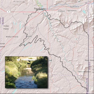
WRIA 56 encompasses the Hangman (Latah) Creek watershed in Washington, with headwaters in Idaho. The basin covers 431,220 acres and contains approximately 222 miles of perennial streams. The headwaters in Idaho lie at an elevation of about 3,600 feet above mean sea level, and at its confluence with the Spokane River the elevation is 1,720 feet above mean sea level.
There are two primary aquifer systems in the Hangman Creek Watershed: 1. an unconfined aquifer in the sand and gravel deposits in the lower portion of the watershed, below the confluence of Rock and California Creek, and 2. the aquifers found in the Columbia River Basalt Group. The water table of the sand and gravel aquifer unit is strongly connected to, and is influenced by, the stage of flow in Hangman Creek. Groundwater discharge from the Hangman valley aquifer and into the lower Spokane aquifer is almost 13 cubic feet per second. The most prolific and important aquifer in WRIA 56 is contained within the Columbia River Basalts where multiply stacked confined or semi-confined aquifers are accessible through deep wells. Due to its limited recharge potential within WRIA 56, the basalt aquifer system may be impacted by increasing groundwater withdrawals into the future.