Spokane River Watersheds
Watershed Planning & Implementation for WRIAs 54, 55, 56, & 57
WRIA 57 Data
 WRIA 57 Web Mapping Application
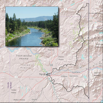
WRIA 57 is located in Northeastern Washington on the border with Idaho, and contains less than 10% of the contributing natural drainage of the Middle Spokane Basin, most of which lies in Idaho. The basin is located on the eastern edge of the Columbia River Basalt Plateau, in the foothills of the Rocky Mountain Range. The principal aquifer in WRIA 57 is the Spokane Valley Rathdrum Prairie Aquifer (SVRP). The SVRP aquifer consists mostly of gravels, cobbles, and boulders. It is highly transmissive and productive aquifer, supplying water to the more than 500,000 residents residing in the area. The uplands are mainly comprised of granite, quartzite, schist, and gneiss. There are usable quantities of water where rocks are fractured, though the yields are usually small
The major drainage of WRIA 57 is the Spokane River. The Post Falls Dam, located nine miles downstream from the outlet of Lake Coeur d’Alene regulates flow in the Spokane River about half the year. Several run-of-the-river dams along the mainstem have minor effects on the Spokane River hydrograph. There is a high degree of hydraulic continuity between the Spokane River and groundwater of the SVRP Aquifer that strongly affects seasonal and annual flows. Between the Idaho-Washington border and the river’s confluence with Hangman Creek, there are several defined gaining or losing reaches. The SVRP Aquifer and its overlying soils are permeable to the extent that streams running off of the adjacent uplands completely infiltrate into the sub-surface at the margins of the aquifer. As a result, there are no perennial tributaries to the Spokane River in WRIA 57 between the state line and Latah (Hangman) Creek, west of downtown Spokane.